
 English
  Russian
Day 4.
Morning with coffee and sheep’s around our house.

Today we need to get to waterfall Glymur – highest waterfall in Iceland. Something around 196 m.
We tried to catch fish in lake by the way. It was the lake , mentioned in the book. We were allowed to fish there. Nothing. Completely nothing. This book allow fishing in flat parts of lakes or in the lakes full off seaweeds. Bad idea! This is very special license!
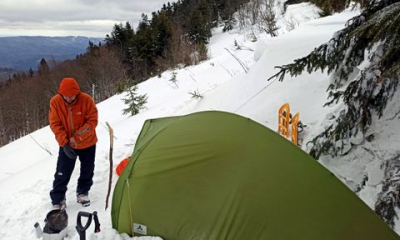
After Borganest we turned inside the fjord Hvalfjordur. At the inner part the normal road became gravel and then parking area appears. From this point need to go by foot. Nobody said that we need alpenstocks and crocks! The slope was strenuous. After rain it can be hardly passable.

The waterfall was hidden inside narrow gorge. It’s very long but not huge. It visible from the right side of slope. And then you can stand little bit upper waterfall and start to cross the river. It’s not deep here. And current is not strong. But water is extremely cold! And of course, stones on the bottom. For this moment we need crocks. But we had not them.

At the end , after numerous attempts to cross river upper, I made this in my trekking boots. My husband and my friends were bare legs. So we appears on left side and follow the trek down. We had been near Glymure approx. 3-4 hours.
Inside the fjord Hvalfjordur there is half peninsula with camping. We came there. But weather start to changing dramatically. It was sunny and hot before. Ana now it was strong wind with horizontal rain. We decided to go direction Thingvellir and try to find there lodging.
It was early evening. Unfortunately this place was very popular with locals. In each possible guesthouse was the same situation – they were fully booked. The only place to stay was camping. But wind was awful. And cold again.
In Lonely Planet I found hotel in this region. And we ride there. It was on southern part of lake Thinvallavatn on road 360.
Nature here was green, hilly, with numerous flowers and small wooden houses with huge windows. The lake was covered with mysterious clouds. Visibility – 15 meters.
Just before the turn to hotel I saw river with steam. I run from the car. Strong wind tried to return me back. The water was hot!!! It was impossible!!!
Hotel Ion stayed not far away from heat station in lava fields. It was luxury and super modern building with open thermal pool. The price was enormous. But it was 10pm, rainy and cold weather and no alternative.
We didn’t take from the car our kitchen staff and food. We took dinner at restaurant))
Day 5.
In the morning I again saw nothing from the window. Mist, wind and rain. Completely.
We took the thermal bath. With hot water and fresh air it was amazing!
This hotel is more busy during winter – skiing, snowmobiles, thermal and Auroras all the time.
Today we get to Thingvellir. Parking area was full. We understand nothing.

So, we pass near huge basalt wall, which follow for kilometers, interrupted only by waterfalls. This place is connection two continental platforms – Eurasian and American. And this platforms are separated on 25 mm every year. But this is not really two wall, which move in deferent directions. One wall is big and great. Then it’s a big field, full of cracks . Mostly cracks are with pure water and its possible to dive and snork here. We walked to the center of plateau. But here was small hill with some archeological remains. Good walk. But just a walk.

Our next point was Kerid volcano on road 35. We didn’t found it ( we found it at our last day).
And I want to get to Hekla in the evening and make ascent next day. We need to follow road 26 and turn on F 225. Just before 5 km before the turn was sign with lodging and food preparations. We turned. Owner give us full house with kitchen and toilet for 5 Euros! Around this charming place there were numerous mushrooms, which we picked up and already cooked.


It was 7 pm when we again follow our way. Sign on to the F 225 not allow us to move farther. This was the road for 4×4. Not 4wd.
But we turned.
Visibility dropped to 2-3 meters. Mist. It’s stupid try to find volcano and get into summit in such a mist. And I decided go to Landmannalaugar – same road, smaller mountains, possibility to see the best and most popular place in Iceland.
As I know we need to cross rivers on F225. You need to cross roads early morning, not early night. It’s because melting of glaciers. During day they make rivers deeper and in morning more shallow.
In one hour we stayed i the bank of unknown river with unknown depth. Next shore was little visible. There were two different directions to cross river. No ideas.

While we stayed and friend told me that we need to turn back, two cars came from opposite side and one from ours. This was dissolve of problem – they show us the wright way – right side and don’t stop!
There were another river by the way but smaller. The mountains became different colors- mostly green, with white orcas spots and yellow and red sides.

Iconical volcano Sutur also situated just 4 km before Landmannalaugar r camp. It has regular conic shape.
Last river before camp was to big for our car and we left it on parking area with other cars. Camp was 1 km ahead. Full of tents and cars. Real touristic hub.

After arriving I ducked into lodging. Here it was possible to stay 60 or 70 persons. I don’t know how they stay but air inside was ugly – unfresh and heavy. There was separate house for showers and toilets and also cooking facilities.
Little bit aside was thermal pool made from piece of hot river. Very relaxing and great place! Temperatures very different – near river 44-46, little aside -41, more aside -36. This pool was one of the best we saw in Iceland!

Day 6.
This night was warm. Tree sheeps came to tents early in the morning.

At 7-30 all our staff was again in the car, we took breakfast and start small trekking around Blue Mountain.
All people in camping slept. As I noted every time we waked up earlier then other. Usually people became to move at 8-9 am.
Trekking pass starts just near the camp. It’s better to do trekking clockwise. Other way it will be very very hard to ascend on the top.


The mountains around are riolite. This is volcanically type with different colors of minerals on the slope. Mostly they are brown, yellow, violet, orange. In some places with blue spots and green moss. Like a picture!


This trekking is not hard. Just 10-12 km with fumaroles on the midway and passing of lava fields at the end.

At 11am we had been in camp in thermal bath. There we had been alone). Nice news!
And start our way back by the road F208 and then road 26. F208 is without any rivers and passable for all kinds of cars.
On road 26 we found fishing on the lake. 30 Euros. At day time fishing here is more or less stupid but there were a lot of mushrooms everywhere.
Our ferry to Vestmannejare departures from Bakkahofn. It’s only 30 minutes to the main and only habitant island Heimaey.
This group of islands are the main point of Icelandic fishing and puffin meat and eggs. In 1963 new small island grows from bottom of ocean because volcano eruption. In 1973 the main island was waked up at 5am by huge eruption- new volcano appears, 400 houses were burned by lava, 2 square kilometers of new land added and port became bigger. People struggle very hard for their existence.
And at the evening we lodged at small guest house on the main Street. Air was full of fish smell! Big factory for drying fish worked in port.